Testing Equipments Supplier
 ISO9001:2015 Certified ISO9001:2015 Certified

loading

TBT-GPR
TBTSCIETECH
| Availability: | |
|---|---|
Application:
Lidar High Senstivity max depth Ground Penetrating Radar is used to detect or identify the information of metal or non-metal targets in a certain depth underground for such as engineering surveys, municipal pipelines, roads bridges and tunnel inspections.It is an asphalt density assessment tool that is ideal for uncovering inconsistencies that occur during the paving process, including poor uniformity and significant variations in density. By detecting these problems, PaveScan RDM 2.0 helps to avoid premature failures such as road raveling, cracking and deterioration along joints.
1.Tunnel inspection: used for tunnel forecasting, tunnel construction quality inspection, etc.
2, Municipal pipelines: identify the distribution of underground metal or non-metal pipelines in the process of urban construction.
3, Road and bridge: make geological body survey for road or bridge siting process. The geological radar can detect all kinds of pavements showing the thickness of each layer but without layer material details, the Radar distinguish the interface of different layers according to the dielectric constant of each layer of materials.
4.Engineering survey: identify the information of bad underground geological bodies such as karst, collapse, broken zone, etc.
Application Recommendation:
Antenna type | Antenna frequency | Up to depth | Application |
Monomer Shielding antenna | 1GHz | 0.5~0.8m | Defect detection of concrete, steel bar and bridge |
400MHz | 1~5 m | Engineering and tunnel lining inspection, retaining wall defect detection | |
200MHz | 1-10m | Shallow layer, engineering, municipal pipelines, environmental exploration | |
Non-shielded antennas | 100MHz | 0~30m | Tunnel Advance Forecast |
The Lidar High Sensitivity Max Depth Ground Penetrating Radar stands out in the market due to its advanced features and unparalleled depth capabilities. Below is a comparison between this product and other similar products available in the market:
| Feature | Lidar High Sensitivity GPR | Competitor GPR (200 MHz) | Competitor GPR (3D Scanner) |
|---|---|---|---|
| Max Penetration Depth | 50 meters (depending on soil) | 30 meters | 25 meters |
| Frequency Range | 100 MHz to 1 GHz | 100 MHz to 200 MHz | 200 MHz to 1 GHz |
| Signal Processing | Advanced Filtering & Analysis | Basic Signal Processing | Advanced Signal Processing |
| Lidar Integration | Yes | No | Yes |
| Real-Time Data Collection | Yes | Yes | Yes |
| Weight | 15 kg | 12 kg | 16 kg |
| Waterproof Rating | IP65 | IP64 | IP65 |
| GPS Compatibility | Yes | Yes | No |
| Battery Life | 8-10 hours | 6-8 hours | 5-7 hours |
Max Penetration Depth: The Lidar High Sensitivity Max Depth GPR offers a deeper penetration compared to competitors, allowing it to detect features as deep as 50 meters, depending on the soil conditions.
Lidar Integration: Unlike many GPR systems, the Lidar High Sensitivity GPR integrates Lidar technology for enhanced surface mapping, which is crucial for both archaeological and environmental applications.
Signal Processing: This radar system utilizes advanced signal processing algorithms, which filter out noise and enhance the clarity of the subsurface data, offering higher precision compared to more basic systems.
Weight and Portability: With a relatively lightweight design, this radar is easy to transport and use in the field, making it ideal for on-site surveys.
Performance Parameters:
Model | TBT-GPR Series Geological Radar |
Antenna frequency | 100MHz/200MHz/400MHz/1GHz/2GHz Optional |
Sampling frequency | 0.2-100Ghz Adjustable |
Time Window Range | 1ns~200000s, Continuous adjustable |
Sampling points | 512~8192 sample Point/scan, optional |
Scan rate | 6~480 Scan/sec, optional |
A/D conversion | 24bit |
Continuous working hours | ≥ 8 hours |
Power consumption of whole machine | < 6 in |
Minimum sampling interval | <2ps |
Measuring mode | Measurement by point, distance trigger, continuous measurement three kinds of measuring methods |
Display mode | Pseudo color, stacked waveform or grayscale |
Operating temperature | -30℃~+70℃ |
Operating voltage | 11-15V DC |
Wireless data transmission distance | Greater than 50 M |
Wired Communications | Ethernet, 100Mbps |
Weight | ≤ 5kg |
Provides multi-parameter verification of spectrum induced polarization for detection abnormality at a certain depth.
At Nanjing T-Bota SciTech Instruments & Equipment Co., Ltd., customer satisfaction is a top priority. We offer comprehensive service and support to ensure that you get the most out of your Lidar High Sensitivity Max Depth Ground Penetrating Radar:
Technical Support: Our team of experts is available to provide technical assistance, whether it's for troubleshooting, installation, or optimization of the radar system.
Training: We offer on-site and remote training to ensure that your team is fully equipped to use the GPR system effectively.
Maintenance: We provide regular maintenance services, including system calibration, battery checks, and performance optimization.
Warranty: The Lidar High Sensitivity Max Depth Ground Penetrating Radar comes with a standard warranty, ensuring peace of mind for our customers.
Upgrades: We offer software and firmware upgrades to ensure that your system remains up to date with the latest technology advancements.
Main features:
1, Optional multi-band antennas allows wide application range. This Radar acquisition system can be formed as diversified frequency center through multiple groups of transmitting & receiving antennas equipped in one system, it can acquisition up to 8 groups of frequencies at the same time. For example, a dual-frequency pipeline detection radar can be equipped with two antennas of 400M+200M, which can obtain high-resolution shallow information and low-resolution deep information in one acquisition.
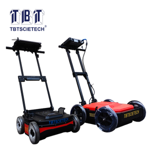
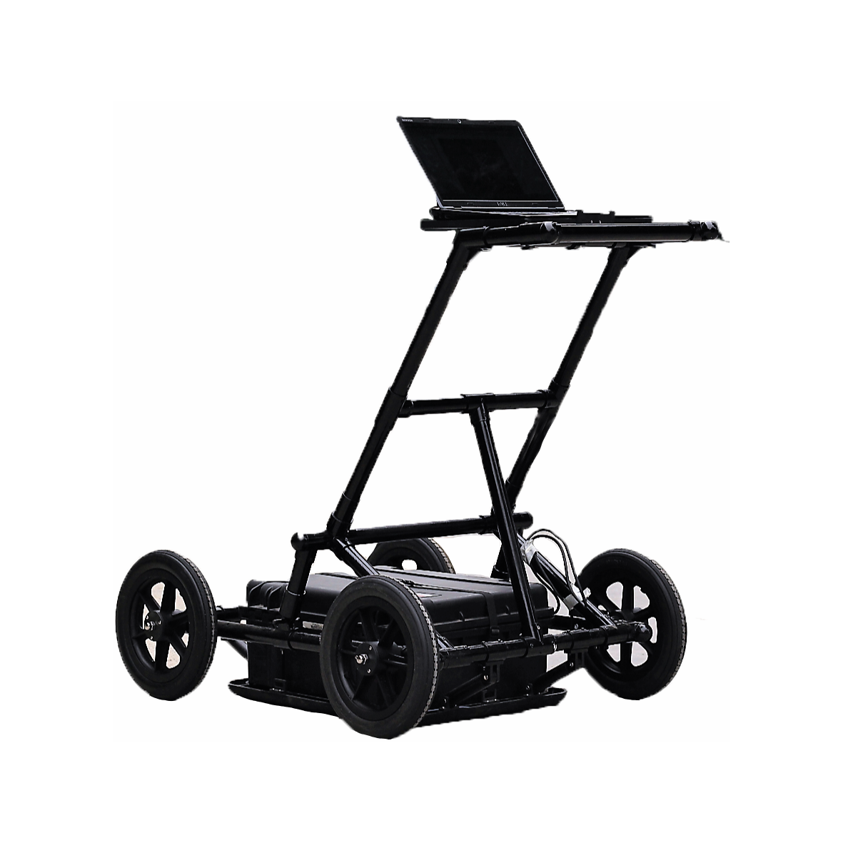
2, The integrated all-in-one compact design, light weight 23kgs (50lbs) and durable, weatherproof materials offers a comfortable & easy-to-steer Radar which can be operated in almost any terrain, can be assembled on site in 2 minutes and fast dismantled for easy storage& transportation.
3, The modular design allows easy to service and to be repaired.
4, Outstanding location performance with good resolution up to 1mm, real-time data collection and display . The powerful DSP core allows sub-surface map real-time display on high-contrast LCD, integrated digital color and gain enhancements maximize the location quality. Advanced digital filtering eliminates unwanted signals and provide greater accuracy.
5, Unique Location Mode is activated simply by reversing the cart, which provides an accurate snapshot of underground conditions with a cursor indicates the depth and location of buried utility.
6, Operating is simple, LCD with keypad and menu easy for user to access the DSP core. One-touch image recording helps easy data storage, images can be saved to flash cards and copied to a PC through third-party card readers.
7, The flashcard interface allows the Radar firmware being upgraded once it available.
8, Built-in super-capacity battery grants long battery life.
Main features:
1, Optional multi-band antennas allows wide application range. This Radar acquisition system can be formed as diversified frequency center through multiple groups of transmitting & receiving antennas equipped in one system, it can acquisition up to 8 groups of frequencies at the same time. For example, a dual-frequency pipeline detection radar can be equipped with two antennas of 400M+200M, which can obtain high-resolution shallow information and low-resolution deep information in one acquisition.
2, The integrated all-in-one compact design, light weight 23kgs (50lbs) and durable, weatherproof materials offers a comfortable & easy-to-steer Radar which can be operated in almost any terrain, can be assembled on site in 2 minutes and fast dismantled for easy storage& transportation.
3, The modular design allows easy to service and to be repaired.
4, Outstanding location performance with good resolution up to 1mm, real-time data collection and display . The powerful DSP core allows sub-surface map real-time display on high-contrast LCD, integrated digital color and gain enhancements maximize the location quality. Advanced digital filtering eliminates unwanted signals and provide greater accuracy.
5, Unique Location Mode is activated simply by reversing the cart, which provides an accurate snapshot of underground conditions with a cursor indicates the depth and location of buried utility.
6, Operating is simple, LCD with keypad and menu easy for user to access the DSP core. One-touch image recording helps easy data storage, images can be saved to flash cards and copied to a PC through third-party card readers.
7, The flashcard interface allows the Radar firmware being upgraded once it available.
8, Built-in super-capacity battery grants long battery life.
Software Applications:
1, Display mode: Real-time color rendering, color/Gray-scale row scan,Variable Area/Waveform display, can be used in linear scanning mode 256A color source to indicate the amplitude and polarity of the signal.
2, The Radar packages enriches the application of system, in addition to equipped with a dedicated radar data processing software, user can choose software module to perform data processing on PC.
The Modules available as:
2.1 Highway surface layer automatic tracking software: specially used for highway detection, removal of interference automatically.
2.2 Highway structure can be stratified and automatically tracked to show the pile number, layer thickness and thickness deviation in spreadsheet.
3, Structure Scan Toolkit: 3-dimensional depth profile, reinforcement mesh perspective, pipeline positioning, building holes, cracks showing.
4, Structure analysis software: Steel bar distribution depth positioning display, municipal pipeline distribution positioning.
5, Bridge structure and rust analysis software: Bridge steel bar distribution and corrosion judgment analysis software.
Configuration: (Standard includes Antenna and EXCLUDES computer)
Item | Qtty | Unit | Description | |
1 | Radar integrated with antenna | 1 | unit | including packing box, transceiver components |
2 | real-time acquisition and analysis software | 1 | set | without lock |
3 | rechargeable battery | 1 | set | can work continuously for more than 8 hours |
4 | charger | 1 | set | can charge fast and charge slowly |
5 | product manual | 1 | copy | |
6 | Professional data processing software | 1 | set | with electronic dog |
7 | measuring wheels | 1 | set | included in the quotation |
8 | professional cart | 1 | pc | included in the quotation |
9 | Optional computer | EXCLUDED in quotation |
The Lidar High Sensitivity Max Depth Ground Penetrating Radar represents the cutting edge of subsurface exploration technology. With its combination of high sensitivity, deep penetration, and Lidar integration, it provides professionals across various industries with the most detailed, accurate, and reliable data available. Whether for archaeology, environmental assessments, or civil engineering, this GPR system offers unparalleled performance and value, making it a critical tool for any field investigation or survey.