Testing Equipments Supplier
 ISO9001:2015 Certified ISO9001:2015 Certified
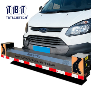
 Views: 187 Author: Site Editor Publish Time: 2020-01-09 Origin: Site


Road surface profiler is a kind of instrument used for measuring the flatness of the longitudinal surface of road, which can play a great role in road management. How does a road profiler work? Why is a road surface profiler necessary?
What is the purpose of the road surface profiler?
What are the main functions of the road surface profiler?
The working principle of road road surface profiler
How to select a road profiler
The international roughness index (IRI) is the roughness index most commonly obtained from the measured longitudinal road section. It is calculated using a quarter car vehicle mathematical model, whose response is cumulative to obtain a roughness index in slope (in/mi, m/km, etc.). Since its introduction in 1986, IRI has become the most frequently used road roughness index for evaluating and managing road systems worldwide. IRI measurements are required for data provided to the federal highway administration and are covered by ASTM International's multiple standards. IRI measurements are also used to evaluate new sidewalk construction and determine fines or bonuses based on flatness.
Road roughness is generally defined as an expression of unevenness in the road surface, which adversely affects the vehicle and therefore the user's ride quality. Roughness is an important road surface characteristic because it not only affects the quality of the ride, but also affects vehicle delay costs, fuel consumption and maintenance costs. The world bank has found that road roughness is a major factor in analyzing and weighing road quality against user cost (UMTRI, 1998). Roughness is also known as "smoothness", although both terms refer to the same road quality. It is often used as a "benchmark" for the level of service on roads or road networks.
From the point of view of customer-oriented service level, high quality road management is widely required on a global scale, so the demand is increasing. In recent years, road managers have been required to create visual maps of the road network to monitor conditions. It is a road profiler, which can easily collect contour data and provide real-time monitoring of road roughness. In addition, the pavement profiler provides an effective way to visualize the collected IRI data as a database of attributes (GIS) and digital roadmap (DRM) in geographic information system.
The dynamic measurement of road contour is accomplished by road road surface profiler. The method includes a sensor (initially ultrasonic, but later laser) that measures the vehicle's height relative to the road. The accelerometer is dual integrated to give the height of the sensor relative to the reference. The difference between the two is the elevation of the road. The elevation profile is then processed to obtain an IRI. The most common method is to measure the IRI in each wheel diameter. Combined wheel diameter IRI is required to obtain the overall IRI "roughness contour".
The main problem with profilers is their contact area compared to the tire footprint. The latter is much larger than any static/slow class 1 prism or typical laser road profiler. Recently, this problem was solved by using a scanning laser to create a 3D model of the road surface. Pavemetrics, for example, has been adopted by many different OEM suppliers of road surface profiler equipment worldwide. In addition to measuring roughness, the system also measures other key pavement attributes, such as cracking, rutting depth and texture.
The sensors, drives, null table, recorder and inductance sensor is one of the main components of pavement profiler, at one end of the sensor rod is equipped with a diamond stylus, stylus tip curvature radius r is very small, when measuring the stylus on the workpieces, contact with the surface being measured vertical, using drive drag sensors at a certain speed.
As the contour of the measured surface fluctuates, the contact will move up and down when the measured surface slides. This movement causes the core to move up and down synchronously through the fulcrum, thus causing the inductance of the two differential inductance coils surrounding the core to change. Sensor coil and measuring circuit is directly connected to the balance bridge, as a result of the change of coil inductance bridge out of balance, and then output a stylus and is directly proportional to the displacement of the up and down the signal, the electronic device will be a weak after the change of power amplification, phase sensitive detection, can get said stylus displacement size and direction of the signal. After that, the signal is divided into three channels: one way is added to the zero indicator to indicate the position of the stylus, and the other way is transferred to the dc power amplifier, which is then amplified to push the recorder for recording. After the other way is amplified by filtering and mean table amplifier, enter the integral calculator for integral calculation, and the surface roughness Ra value can be read directly from the indicator table.
Selecting a road surface profiler requires analysis of performance specifications such as vertical range, vertical resolution, horizontal range, horizontal resolution, scan or transverse length, scan rate, part diameter or width. The vertical range is a range of surface texture or peak-valley distance or height that can be measured by a pavement profiler. Vertical resolution is the minimum contour height resolution that the road surface profiler can achieve. The transverse range is the spatial or linear range within which the instrument can measure the entire sample or surface. For the measuring surface roughness of the surface road surface profiler, the pavement profiler is parallel to the surface of the parts. Lateral resolution is the minimum available profile peak, valley, or pitch resolution. The scanning or transverse length is the entire distance from which the pen is optically scanned or drawn during the data collection operation. The scan rate is the speed required to optical scan or drag the stylus horizontally during contour data collection.
Road profilers are very useful tools, so carefully select qualified road profilers is very important. If you are looking for a reasonably priced high quality road surface profiler, NANJING T-BOTA SCIETECH INSTRUMENTS&EQUIPMENT CO.,LTD can provide you with the best products.